Google Earth is an amazing free tool provided by Google. It is a geobrowser that allows you to see geo-coded information of all kinds viewed against a background of dynamically- and seamlessly-rendered satellite photographs. You will see the world in a totally new way.
For those who are new to Google Earth there is a download guide and a comprehensive User's Guide available.
The College of Exploration's World Ocean Day Online Festival can be visited using two new layers of information developed for (and during) this online festival. These layers are files specially coded in the Keyhole Markup Language (kml).
The first thing you need to do after you have installed
and started Google Earth is to download the events
and/or contributions kml files to your download folder.
While it is possible for you to configure your computer
or web browser to recognize automatically that kml
files associated with the Google Earth application,
it is easier to simply open up your installed Google
Earth application and then the File/Open menu item
to load the kml file into your "Places" panel
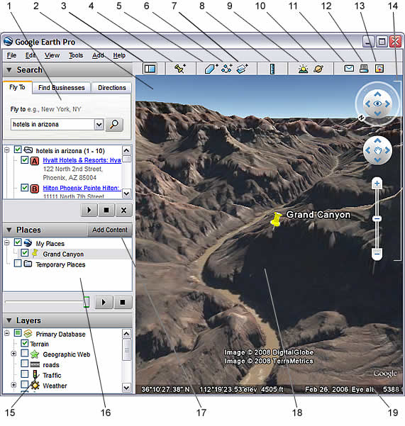
(see area #14 on the following diagram from the User
Guide).
Each geo-coded event or contribution is attached to a pushpin icon (see #15 above) at its location. You just need to click on this pushpin icon to open up a small window of information and links to a public webpage that shows comments related to this event or contribution or that opens up a Caucus conference response window to add in your own comments (login required).
While you can navigate around the globe (using the navigation tools explained in the User Guide) looking for pushpins to explore, you can also click on an event or contribution in the WODOF_07_Events or WODOF_07_Contributions layer in the "Places" panel (see #14 above) and the large right panel will reorient itself to the associated location.
If you want to take a tour of the events or contributions you can click on the layer's name in the "Places" panel (see #14 above).and then on the triangular "tour" buttonbelow on the bottom right. This will reorient the globe image to each successive pushpin icon. It is a great way to get an overview.
If you are want to find the longitude and latitude coordinates associated with your contribution, you can navigate Google Earth to a point where you can place the cursor over the exact spot. You can then read the coordinates off of the line at the bottom of the right panel (see #16 above). (You will want to make sure the the coordinates are in digitial degrees by selecting the "degrees" format in the Show Lat/Long section of Google Earth > Preferences > 3D View (for Mac) or Tools > Options > 3D View (for Windows/Linux).)